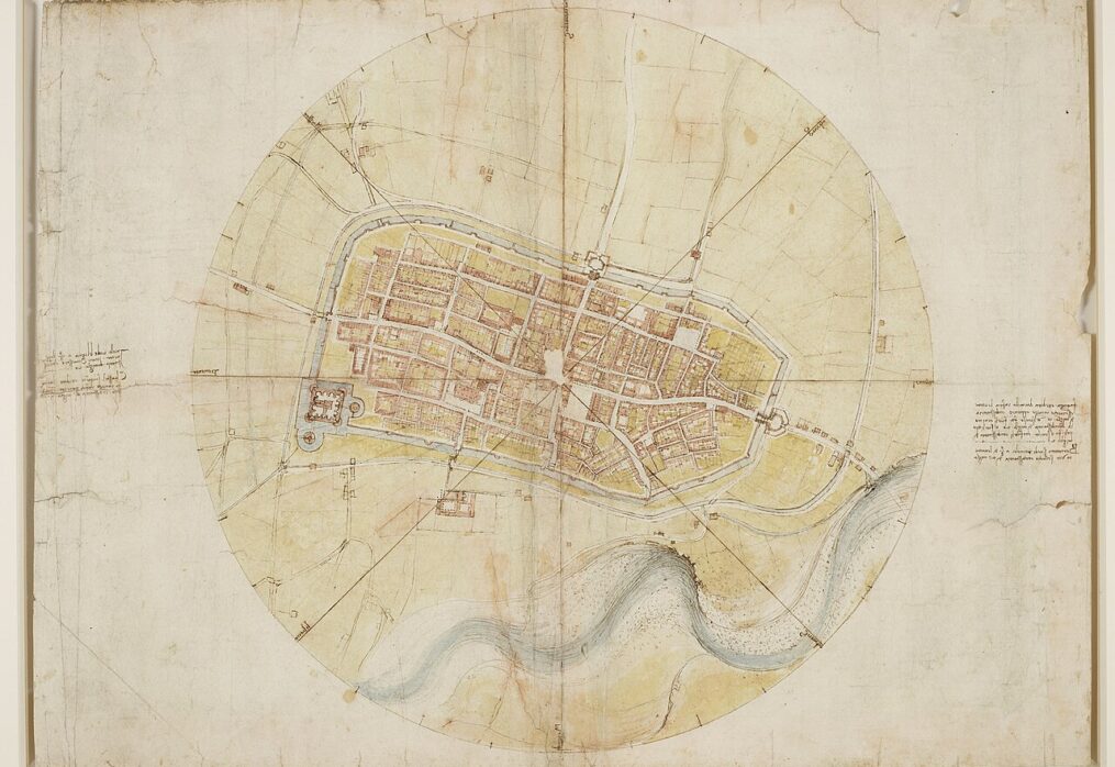

From the map of Imola to his studies of Tuscany’s rivers, Leonardo transformed observations and measurements into maps that helped him understand the landscape and plan changes to it.
Leonardo da Vinci was also a cartographer, mapping cities, rivers, mountains and landscapes through direct observation and applying his knowledge of geometry and drawing. Leonardo’s maps were used to plan changes to the landscape, as demonstrated by his cartographic studies of Tuscany and the Chiana Valley, where he depicted waterways, hills and drainage basins, partly to investigate land reclamation and canal construction projects. Another remarkable example is his map of Imola, created in 1502 while working for Cesare Borgia. It shows the city from above, even though Leonardo had no means of observing it from that perspective. Instead, he reconstructed its layout using ground surveys, distance measurements and compass directions.
TABLE OF CONTENTS
- How did Leonardo draw maps from above?
- The map of Imola
- Leonardo’s maps of Tuscany
- What were Leonardo’s maps used for?
How did Leonardo draw maps from above?
Today, we are used to viewing cities and landscapes through aerial photographs and satellite images, but in Leonardo da Vinci’s time, mapping a territory from above was far from easy. There was no way to fly over a city to observe its layout, so cartographers had to reconstruct it using information gathered on the ground.
Leonardo therefore combined direct observation, distance measurements and geometry. He walked along streets, identified landmarks and studied the orientation of buildings to reconstruct how different elements were arranged in space.
Transforming observations made from different perspectives into a unified bird’s-eye view was certainly no easy task. Yet, in his maps, Leonardo used drawing to create an overall picture that no observer could have obtained from ground level.
Inside Leonardo’s World
Experience interactive machines and inventions at the Leonardo Da Vinci Exhibition in Rome
The map of Imola
In 1502, Cesare Borgia appointed Leonardo as his chief architect and engineer, entrusting him with tasks involving the surveying of territories and the defensive structures of the cities under his control.
It was in this context that Leonardo created the map of Imola, which could provide Cesare Borgia with valuable information about access routes, streets, fortifications and connections, all essential for the military and administrative control of the territory.
Leonardo’s map depicts the city from a vertical perspective, showing streets, blocks, buildings and fortifications within the city walls. A circle divided according to compass directions surrounds the city, while annotations indicate orientations and distances to other locations.
To create the map, Leonardo surveyed the streets, recording measurements and the layout of different neighbourhoods. He is also believed to have used observations from elevated viewpoints and his knowledge of geometry, while certain details suggest that he may have consulted earlier cartographic documents.
The result is a map in which spaces are organised and measurable, with the city’s proportions and layout represented with remarkable accuracy for the period, although not entirely without inaccuracies.
Leonardo’s maps of Tuscany
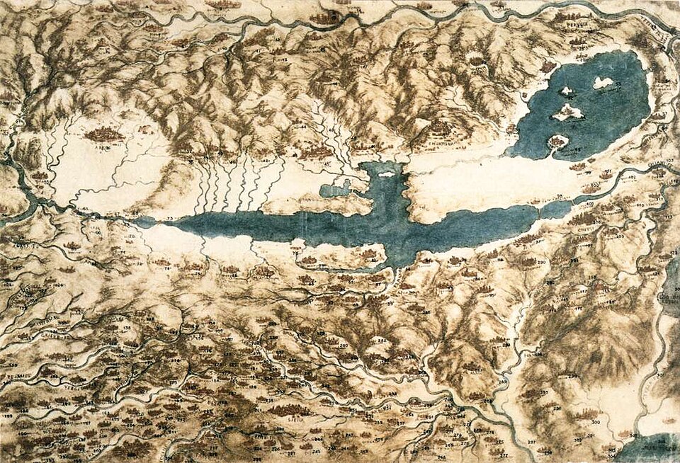
Following his experience in Romagna, Leonardo continued his cartographic work, paying particular attention to Tuscany, the Arno Valley and the Chiana Valley.
In these drawings, Leonardo went beyond depicting cities and roads, focusing also on the shapes of mountains and the arrangement of valleys, lakes and waterways, seeking to illustrate the relationships between natural features.
In his maps of the Chiana Valley, produced in the early 16th century, he used colours and shading to distinguish hills, plains and bodies of water, combining geographical information with artistic techniques to make the landscape’s features easier to understand.
This attention to the landscape served a practical purpose, as understanding the location of plains, drainage basins and the course of waterways was essential for assessing land reclamation, hydraulic engineering and land management projects.
Leonardo’s interest in cartography was closely connected to his studies of water. His manuscripts contain observations on currents, whirlpools, riverbank erosion and sediment transport, all phenomena that continuously reshape the landscape.
Leonardo’s maps therefore illustrated the relationships between mountains, drainage basins, rivers and plains, providing a basis for considering possible engineering projects. This was the case with his studies of the Arno, for which Leonardo explored proposals for canals and alterations to river courses. Some drawings show planned canal routes intended to improve connections and transport between different areas.
Although not all these projects were carried out, the maps demonstrate Leonardo’s determination to understand how a landscape functioned before attempting to modify it. They also reveal how cartography formed an integral part of his work as an engineer, helping him assess slopes, distances, water flow and terrain in order to design engineering works.
What were Leonardo’s maps used for?
Leonardo’s maps were used to study a city’s defences, plan routes, explore territories and design hydraulic engineering works or other projects.
The map of Imola, for example, was intended for urban and military control, while his studies of Tuscany highlight the relationship between geographical representation and landscape planning.
What Leonardo’s maps have in common is primarily the method used to create them. By collecting data and conducting surveys, he combined drawing, geometry, mathematics, observation and engineering to understand, represent and plan changes to the landscape.
Not all his maps were alike. Depending on their purpose, Leonardo sometimes prioritised geometric accuracy, while in other cases he used colours, shading and perspective views to make mountains, valleys and waterways easier to identify.
Leonardo Live
Visit the Leonardo Da Vinci Exhibition in Rome and discover his machines, inventions, and much more first-hand.
You can read the Italian version of this article here >